Madambakkam Lake row raises larger question: How was real-estate development cleared before wetland status was settled?
A 3-metre WRD setback met planning conditions on paper. The larger issue is whether permanent layouts should wait for wetland boundary, high-flood level and zone-of-influence mapping.
Residents say construction is advancing beside Madambakkam Lake while wetland demarcation remains pending — and ask what environmental checks CMDA completed before December 2024 layout approvals.
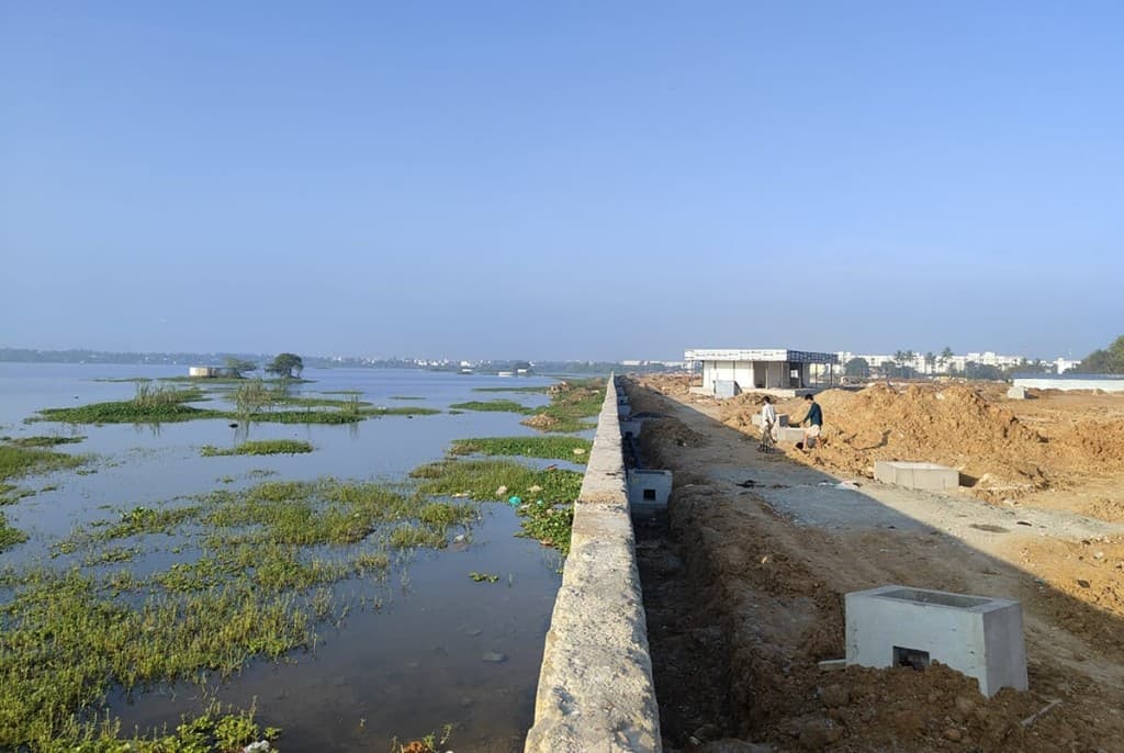
Madambakkam Lake row raises larger question: How was real-estate development cleared before wetland status was settled? — Environment, Chennai local news
Location
Chennai, Tamil Nadu
Published
30 Sept 2026
Topic
Environment
Primary source
Wetlands (Conservation and Management) Rules, 2017
Status
Published & verified editorial
Official government order
Wetlands (Conservation and Management) Rules, 2017
What we know
Summary
Chennai, 30 September 2026 — Residents and environmental groups have renewed objections to real-estate development along Madambakkam Lake near Tambaram, arguing that construction is moving ahead while the lake’s wetland boundary, hydrology and legal protection remain under official scrutiny.
The dispute also raises a sharper planning question: how were layout approvals processed by the Chennai Metropolitan Development Authority (CMDA) when multiple environmental proceedings relating to the lake were already underway?
A dispute over residential layout development abutting the lake has brought CMDA, the Tamil Nadu State Wetland Authority and the Water Resources Department under renewed scrutiny. Residents and campaigners allege that land adjoining the lake is being developed with insufficient protection for the waterbody and its floodplain.
The issue is more complicated than a simple “50-metre buffer violation.” Official records point to an unresolved conflict between planning approvals already granted, landowners’ claims over patta land, ISRO wetland mapping and an ongoing government exercise to physically demarcate the wetland.
The central question is therefore not merely whether somebody has built too close to a lake. It is:
Should a major residential development have been allowed to proceed before the wetland boundary and its environmentally sensitive zone were conclusively established?
What is happening at Madambakkam?
The disputed properties are reported to include lands in and around Survey Nos. 768, 769/1 and portions of Survey No. 723 adjoining Madambakkam Lake.
Tribunal and planning records show that landowners proposed residential layouts on these properties and that CMDA granted layout approvals in December 2024. The approved plans reportedly incorporated only a 3-metre no-development buffer on the southern side adjoining the lake, based on conditions communicated by the Water Resources Department. A peripheral storm-water drain was also prescribed.
Residents and environmental groups contend that such a narrow setback is inadequate given the ecological character of the lake, its flood-storage function and its identification in wetland mapping exercises.
Residents have sought intervention from CMDA, the Water Resources Department, Tambaram Corporation, the Tamil Nadu State Wetland Authority and the National Green Tribunal.
Why Madambakkam Lake’s wetland status matters
Madambakkam Lake has been identified in ISRO’s National Wetland Inventory and Assessment datasets, according to the Tamil Nadu State Wetland Authority.
In June 2025, the Wetland Authority said petitions concerning development near the lake required the authorities to verify its actual extent. It directed officials to carry out ground truthing, survey and shapefile-based demarcation.
A Chengalpattu District Collector report subsequently recorded that the State Wetland Authority had issued directions on 28 May 2025 for ground verification, survey and demarcation. A subcommittee was constituted by the District Forest Officer, but the process remained pending when the report was filed.
That unresolved demarcation is crucial.
Satellite identification tells authorities that a wetland exists. Ground truthing establishes precisely where the wetland extends on the ground, how its hydrology operates and which parcels overlap or interact with it.
The Supreme Court has already addressed this national problem
The issue is not unique to Madambakkam.
On 11 December 2024, the Supreme Court noted that ISRO’s 2021 wetland atlas identified approximately 2,31,195 wetlands larger than 2.25 hectares across India.
The Court observed that states had largely failed to complete the required ground-truthing and boundary-demarcation exercise and directed State and Union Territory Wetland Authorities to complete it for wetlands identified in the Space Applications Centre atlas. Later orders reiterated the requirement and pressed states to accelerate the exercise.
This gives the Madambakkam controversy a wider significance: urban development appears to be advancing in parts of India faster than environmental authorities are completing the basic exercise of identifying and legally securing wetlands.
Is there really a mandatory 50-metre buffer?
This point requires precision because several social-media explanations oversimplify the law.
The Wetlands (Conservation and Management) Rules, 2017 do contain a 50-metre provision. Rule 4 prohibits permanent construction, except boat jetties, within 50 metres from the mean high flood level observed during the preceding ten years. The Ministry of Environment’s official implementation guidelines reproduce this requirement.
But describing this simply as a universal “50-metre buffer outside every lake boundary” is inaccurate.
The reference point is the mean high flood level, not necessarily the current FMB / revenue boundary or visible shoreline.
That distinction is particularly important in urban lakes where historical water spread, flood levels and present cadastral boundaries may differ significantly.
There is another legal complication
Under the literal structure of the 2017 Rules, their principal application is to Ramsar wetlands and wetlands formally notified under the Rules.
However, the Supreme Court had previously directed protection of the wetlands identified in the earlier National Wetland Inventory, and the Union Environment Ministry subsequently clarified that these wetlands should receive Rule 4 protection irrespective of whether individual notification had been completed. Tribunal proceedings continue to rely on that interpretation.
This is why the argument that “Madambakkam has not yet been formally notified, therefore wetland restrictions do not matter” is not legally straightforward.
Why CMDA’s role deserves examination
The issue is not necessarily that CMDA knowingly violated wetland law.
The more important governance question is whether the planning approval process had sufficient environmental information before approval was issued.
Official tribunal records indicate that CMDA-approved layouts incorporated only a 3-metre buffer adjoining the lake based on WRD requirements.
At the same time, subsequent proceedings show that authorities were still attempting to establish:
- the actual wetland boundary;
- historical land classification;
- the extent shown in ISRO wetland datasets;
- drainage and flood characteristics;
- and the relationship between private survey fields and the lake.
If those matters were unresolved, approving permanent development immediately beside the disputed ecological boundary creates an obvious planning risk.
The correct question for CMDA therefore is not: “Did you know the Wetland Rules existed?”
It is: What environmental verification was completed before planning permission was granted?
CMDA would ideally place the following information in the public domain:
- Approved layout plans and planning-permission conditions.
- WRD NOC and the basis for prescribing the 3-metre setback.
- FMB and authenticated lake-boundary maps used during scrutiny.
- Whether ISRO NWIA layers were examined.
- Whether Tamil Nadu State Wetland Authority clearance or consultation was obtained.
- The high-flood-level data used for the site.
- Whether cumulative flood risk was assessed.
- Whether development was approved before or after authorities became aware of the ongoing wetland dispute.
The landowners’ position must also be recorded
The controversy has another side.
Landowners have asserted before authorities that the disputed properties are privately owned patta lands, with title documents tracing ownership back several decades.
An affidavit referred to in tribunal proceedings states that approximately 14.48 acres across Survey Nos. 768, 769/1 and parts of 723 are privately owned.
The owners have also argued that Madambakkam Lake did not appear in a particular MoEFCC list they examined and have questioned whether the concerned private survey fields legally form part of the wetland.
This is precisely why a scientific, cadastral and legally authenticated demarcation is necessary.
Private title and environmental regulation are not mutually exclusive. A parcel can be privately owned while still being subject to restrictions arising from drainage, floodplain, wetland or environmental laws.
A troubling sequence
The chronology raises the strongest questions.
- 2024: Residential-layout applications were processed, and CMDA approvals were reportedly issued on 23 December 2024.
- 11 December 2024: The Supreme Court directed states to complete ground truthing and demarcation of wetlands identified in the SAC / ISRO atlas.
- 2025: Tamil Nadu State Wetland Authority specifically directed ground truthing and demarcation of Madambakkam Lake.
- 2025–26: NGT proceedings continued over sewage, wetland status, historical classification and protection of the lake.
- 2026: Residents say development activity is continuing while these fundamental questions remain unresolved.
The administrative sequence therefore deserves examination.
What this means in Chennai
Local impact, institutions, and what residents should watch next.
Why this matters beyond Madambakkam
Wetlands surrounding Chennai are not simply vacant lands containing water.
They function as components of a larger hydrological network. They can:
- store monsoon runoff;
- reduce peak flood flows;
- recharge groundwater;
- support biodiversity;
- receive and convey drainage;
- connect neighbouring tanks and channels;
- and provide flood-storage space during extreme rainfall.
The MoEFCC’s own implementation guidelines require authorities to look beyond the visible wetland boundary and identify a “zone of influence” based on hydrology, drainage and surrounding land uses.
For a wetland with a defined drainage network, the guidelines say its directly draining basin may form the relevant zone of influence.
That approach is fundamentally different from treating the lake as a blue polygon on a cadastral map and permitting construction immediately outside that line.
Chennai’s flood risk is not only about one lake edge. Neighbourhood-level patterns are also tracked on our flood street-score desk.
The Madambakkam question is ultimately a planning question
Chennai’s peripheral areas are urbanising rapidly.
Tambaram, Selaiyur, Madambakkam, Vengaivasal, Sithalapakkam, Perumbakkam and adjoining areas contain numerous historical tanks, channels and low-lying drainage corridors while simultaneously experiencing intensive residential development.
The planning system therefore needs to answer a basic question before approving construction:
Where will the water go?
Determining that after layouts are approved, plots are sold and houses are built is too late.
For Madambakkam, the immediate requirement is consequently not speculation over whether every square metre is legally wetland.
It is transparency.
The government should publish one authoritative GIS map showing:
the surveyed lake boundary + ten-year high-flood level + ISRO wetland polygon + WRD boundary + FMB survey fields + inlet/outlet channels + zone of influence + CMDA-approved layout.
Once these layers are placed together, much of the present dispute can be objectively examined.
Until such demarcation is completed, allowing irreversible construction on land whose hydrological relationship with the lake remains disputed creates unnecessary environmental, legal and financial risk for residents, government agencies, developers and future homebuyers alike.
Official sources
This page is an editorial rephrase and analysis based on publicly reported information. Read the original source for full context.
FAQ
Not in the oversimplified sense often shared online. The Wetlands Rules, 2017 prohibit specified permanent construction within 50 metres of the mean high flood level of the preceding ten years — not automatically from every revenue shoreline or FMB line. Applicability also depends on wetland inventory protection, notification status and site-specific zones of influence.
Explore the site
More from mychennaicity.in
Chennai today, local news, jobs, events, gold rate, and a moderated WhatsApp community — one city desk.
- Chennai today60-second morning card
- WhatsApp communityModerated Chennai updates
- Chennai local newsCivic desk & neighbourhood stories
- Afford this areaTake-home vs rent check
- Jobs in ChennaiOpen roles across the city
- Which Chennai are you?Playful neighbourhood quiz
New here? How to use mychennaicity.in — guides for residents, job seekers, admins, and more.
Promote your business to Chennai readers
Get visibility across local news, events, jobs and area pages.
Reader group: The my chennai city reader group — short updates and civil discussion, same standards as the site. Opens WhatsApp after you tap.
Tip the Chennai desk
Spotted something we should look at — safety, civic works, consumer rip-offs, or a human story? A short message is enough; links and dates help.